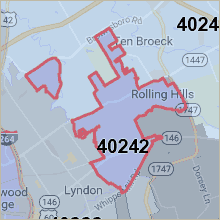
This smaller, east-end ZIP actually has two pieces. The larger piece centers on Westport Road but another, tiny piece holds a couple of neighborhoods off Highway 22. It is just 2 miles in radius and is located within Jefferson County.
Active Listings 40242
Louisville Neighborhoods in 40242
According to the United States Postal Service, the following are cities located within this ZIP code.
- Briarwood, Kentucky
- Langdon Place, Kentucky
- Lyndon, Kentucky
- Meadow Vale, Kentucky
- Murray Hill, Kentucky
- Old Brownsboro Place, Kentucky
- Plantation, Kentucky
- Rolling Hills, Kentucky
- Louisville, Kentucky
These are the Louisville neighborhoods located within the 40241 ZIP code. There may be others as well, that are partially inside this ZIP or unregistered entities.
- Autumn Ridge
- Ballantrae
- Bancroft
- Barbourmeade
- Briarwood
- Brownsboro Gardens
- Brownsboro Meadows
- Brownsboro Vista
- Colonial Terrace
- Dove Creek
- Eagle Creek
- Ewing Place
- Goose Creek
- Harmony Place
- Holly Point
- Holly Springs, Holly Springs Village
- Lancaster Manor
- Langdon Place
- Lyndon
- Meadow Vale
- Murray Hill
- Old Brownsboro Place
- Plantation, Plantation Hills
- Rolling Hills
- Westmoorland
- Westwood
- Whipps Mill Village
This list is not exhaustive but covers most subdivisions in 40242.
Want to Sell Your Home in 40242?
The first step is finding out what your 40242 home is worth. It will be my pleasure to serve you!
I'll come by your home for a quick tour, then I'll create a custom Current Market Analysis (CMA) for your home, based on the best, recently sold comps. We'll schedule a time to meet and discuss the findings and take it from there. No obligation whatsoever.
As Louisville's real estate expert, I'll do the best job of getting your home more exposure to more home buyers than other agents. This means selling your home faster and a higher price. Contact me and we can get started!
Neighborhood Map

40242 Demographics
Population: 10,982Median Age: 38.2
Household Size: 2.42
Maps on Google: 40242
